Wednesday, February 28, 2024

Laying out the Russina Spur


Modeling the AT&SF - D&RGW Joint Line through Colorado Springs from Milepost 70 to Milepost 80 circa 1978-1979

- ~ -

Post 3: Recent layout progress

Laying out the Russina Spur industrial park

After a  long break I’ve been busy working on the layout over this past Fall and Winter months, making good progress planning things out full size in three dimensions before I cut and screw lumber together, lay track and run wiring. Cardboard and pencil lines are so much easier to change when it becomes clear that things just won’t fit as originally envisioned or even as drawn in CAD. Using actual turnouts and building mockups made quickly out of scrap foamcore and matt board are great reality checks to help verify track and building locations, orientations and sizes, and they are easily changed or added to using an Olfa knife and a hot glue gun. Plus they will be useful stand-ins until the actual model buildings can be constructed—and there will be a lot of them to build!

This is the first of several rather long posts as there is a lot to catch up on, and there is more to come. Below are some photos and descriptions of the process as of late February, 2024. I've also updated the layout plan to reflect recent progress and changes.

(click on images to open a larger view, open in a new Tab or Window to be able to toggle)

- ~ -
 
 
USGS 1975 (modified)
 

Work in the Fall first focused on the Russina Spur that served the industrial park to the west of the mainline. Below is an old view of the layout at Russina, but little has changed along the mainline here other than plywood has now replaced the cardboard. What is new is what has happened to the left of the pink foam board. 


First a recap of Russina. On the far side of the main here is a double-ended switching lead along the east side of the main. Apparently this lead was only ever tied into the main at one end, but which end changed over time. Originally the switch was at the north end, hard against the Garden of the Gods Road grade crossing, but after a grade separation project that depressed the road and elevated the track the connection was changed to the south end. I’ll be keeping the grade crossing but connecting the siding at both ends to make it a runaround, as I don’t have room to put a runaround up on the Russina Spur where it actually was.

A stub track off the switching lead serves Pike’s Peak Distributing (center right), the large Budweiser distributer for the Springs area. With Fort Carson, Peterson Air Force Base, NORAD, and the Air Force Academy all located in and around the Springs they sold a lot of suds and received regular rail shipments in white 50 and 60 foot Manufacturers Railway insulated RBLs.

Weicker Transfer also had a storage warehouse beside the lead here (to the left at upper center). I don’t know if it ever had rail service, but I intend to model buried ties beside the building without rail to suggest that it once did but no longer does.

The pink foam board along the aisle is the eastern edge of the bench that the industrial park sits on, and the heavy dark centerline in the foreground is the start of the spur that serves it.

- ~ -


My task this past Fall was working out the geometry and track arrangement for the stub peninsula to the west of the main that would be the home of the Russina Spur, listed as a track between stations in the Joint Line employee timetable. Here’s what the area beside the main line looks like. It is very busy, dense and complicated, but keep in mind that I’m only interested in the buildings along the bottom edge with direct rail access, the rest will be out in the aisle. Simplify, simplify, simplify is the order of the day here.

  
Google Earth
 
Development of the industrial park here began in 1960 on a parcel of land located on the stepped mesa to the west of the Rio Grande mainline. Access required a sharply curving spur off the main that climbed a steep grade along the north edge of Douglass Creek ravine (bottom left and far left). A concrete “tunnel” was buried beneath the Valley Expressway (now Interstate 25), which was being constructed at the same time (upper left), and a runaround siding and tail track was installed immediately west of the highway along the lip of the ravine (top left, but pulled up in this view).

Two trailing turnouts east of the highway led to customer spurs inside the curve on the bench between the highway and the main line. One was very short and served only the warehouse of Johnson Storage & Moving, the agent for United Van Lines in the Springs (the two finned tilt-up buildings linked by a low connecting annex at center left). The other was a much longer spur running parallel to the Russina Spur and mainline that could serve multiple customers.

It was a tricky challenge working out the track radii, grades, turnout locations, building sizes and placement here. I didn’t want it to look too crowded or too model railroady, so several buildings were omitted and others were compressed. In my modeling era the switch to the moving company was spiked, but the longer spur served two customers: Dry Wall Products (center), which received bulkhead flats and boxcars of gypsum wall board, mud, steel studs, and foam insulation board in an open unloading area for storage in several sheet metal buildings; and Mountain Wine & Spirits, a beverage distributer operating out of a larger concrete warehouse (center right). I only have to suggest the DWP buildings as they would mostly be in the aisle, but I will have to model a bit more of the beverage distributer warehouse.

  
Frank Keller photos

Here’s the start of the Russina Spur at the turnout off the main line, with Pike’s Peak Distributing across the main and Weicker further north. Notice the electric lock and timer on the switch and a small relay cabinet to the left, as the Dispatcher must authorize access to and from the CTC mainline here.


This view looking east shows the Russina Spur curving sharply as it climbs the steep grade up from the main line. Douglas Creek ravine is between the fenced parking area in the foreground and the Johnson warehouse. Inside the curve is the first customer spur, wrapping around the Johnson warehouse and then levelling out onto the bench to run parallel to the mainline. The second spur to Johnson is just visible entering at far left, ending just to the right of the dock and garage door at a crossed tie wheel stop. Across Monument Creek valley to the east is Austin Bluff, which will be rendered on the backdrop.


And here is the scene as it will be depicted on the layout. The Russina Spur is a 26 inch radius, the customer spur is 24 inch. One might question featuring such a large building when it isn’t even an active rail customer anymore, but it is a signature structure that anchors the entire scene in place. I’m using kit wall sections to model this and other distinctive double T-fin concrete tilt-up wall panel buildings. Great West Models once made these modular wall panels in molded styrene, but the company is long gone. Fortunately one of Walthers’ Cornerstone kits depicts walls of this type (Modern Concrete Grocery Warehouse, kit 933-4105). This style of building was quite common in the Springs, probably because Stresscon has a large plant in the area that manufactures reinforced cast concrete wall, floor and roof panels, bridge beams, and the like.


First in on the long customer spur is the Dry Wall Products spot. Wrapped gypsum wall board and insulation board was unloaded by forklift here and moved to the lean-to sheet metal storage buildings in the distance.


This view from the west looks back toward the unloading spot at the far treeline. Walthers makes an almost perfect match for these steel lean-to sheds (two are included in their Modern Lumber Transload, 933-4106; one is also included in kits 933-3347, 933-4108, and 933-4119).


The other customer on the long spur is liquor distributor Mountain Wine & Sprits. It operates out of another Twin-T tilt-up building. There are actually three of this style building along the spur north of DWP, but only this one needs to be modelled.


Here is what the spur will look like on the layout, as photographed through the conveniently not-yet-installed backdrop. That is one of the Walthers steel sheds cut in two and placed open-side against the edge of the layout.

- ~ -


I don’t have enough room to fit all of the Russina Spur in its entirety, so I omitted the I-25 “tunnel”, seen here along with the turnout for the short spur to the Johnson warehouse. The Russina Spur was eventually extended on a northwest heading up Douglas Creek draw to where it crossed Valley of the Gods Road at grade (also omitted), then it curved west to run parallel with the street a short distance, ending at Forge Road.


In this view taken right above the grade crossing the Russina Spur is curving west behind the bushes at the left. The white building beyond the bushes is Dixon Paper, while the metal buildings up on the mesa are part of the Western Forge plant.

In the second view we see the right-of-way running behind and past Dixon Paper. The rails are still in place, but heavily overgrown.


On the layout I extended the Spur curve to form a reversed J with the long stem running parallel to the main line, creating a short but generous 34 inch wide alcove operators aisle between the peninsula and the mainline.


To fit the peninsula J the curve is reversed from the prototype as the track runs behind Dixon Paper. It will be built using wall parts from a different Walthers Cornerstone kit (Modern Concrete Warehouse, 933-4067).

Dixon Paper was a Colorado-based distributer with branches in several cities in the state. Their Colorado Springs warehouse had a spur that ran into the rear of the building for protected unloading out of the elements, with truck docks at the front of the building. This view shows the building in later years repurposed as a retail operation, with the remnant Spur still in place but paved over to the west. Above it you get a glimpse of the sprawling nature of the eastern end of the Western Forge plant.

  
Google Earth (modified)


Dixon Paper as it will be on the layout with the Western Forge buildings beyond to the left.
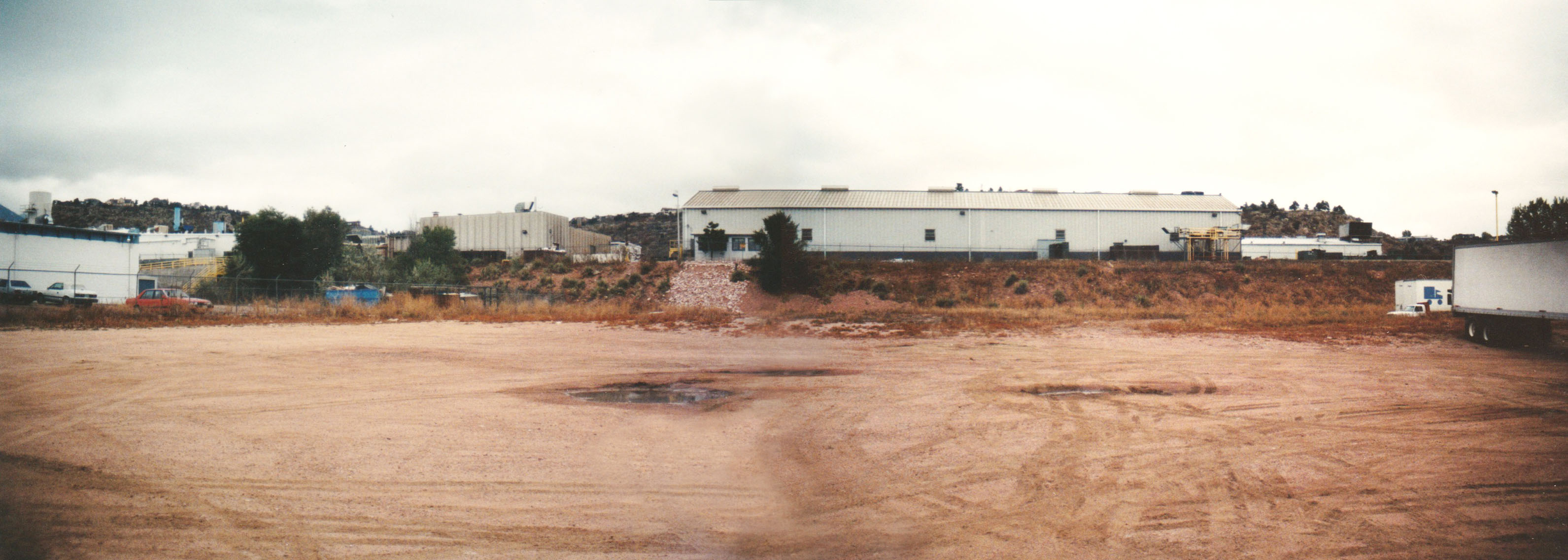


In my modeling era the area to the west of Dixon Paper was just an open vacant lot and truck park. At far right you can see Dixon semi-trailers parked, with Western Forge buildings at top center.

This view shows the trailing point turnout of the spur into Dixon Paper. The T-fin building was not rail served, but it will be on the layout.


Google Earth (modified)

Forge Road at left is of course named for Western Forge, a large, low-rise plant of multiple concrete and metal-sheathed buildings (think Pikestuff). The company manufactured hand tools for several name brands, notably the Sears house brand Craftsman line. If you own any Craftsman drivers, pliers or wrenches bought before production was moved off shore they came out of this plant. I haven’t been able to definitely establish that WF ever used rail service, but it will in my world, receiving gondola loads of steel bar and rod stock and covered hoppers of plastic resin pellets and rubber for molding tool grips and handles.


This view looks past Western Forge Plant 3 on the left toward Plant 2 in the distance. Although Plant 2 was still much higher here, notice the ramp down to the lower level. This suggests that rail service to the plant was a plausible scenario, one that I will take advantage of, although I will be placing Plant 2 at the same elevation as Plant 3.


This is Plant 2 looking east from Forge Road, with plenty of roof clutter, blower ducts, platforms, and a large dust collector. This is the kind of alley between plant buildings that I want to suggest. The only thing missing are a security gate house and silos for plastic pellets.

Both of those existed a bit further up the street at Plant 4, where molded handles and grips were formed around the forged tool bodies. I intend to transplant both the tanks and the guard shack over to Plant 2 to create a composite of the complex.


To support their traffic I am giving WF its own multi-spot spur buried in the alley pavement between its plant buildings. This keeps the lead open for switching Dixon Paper’s spur without interfering with cars spotted for WA, plus it makes it easier to switch the WF track. This is a satellite view that I have sliced, diced, compressed and reassembled to create my concept of how to model the area.


And this is how I have laid out Western Forge as it will be on the layout. Obviously I ran out of cardboard here, but you get the idea. Plant 3 is a simple concrete block building, while Plants 2 and 4 will be constructed of Pikestuff wall sections. The pellet silos are Walthers parts (933-3081, also included in their Magic Pan Bakery, 933-2915), but they need to be reduced to just over half their height. Walthers also makes a suitable large dust collector and bin (933-4087).

- ~ -


And that’s how I plan to tackle the Russina Spur. I think working it should be a fun job that will keep a 1-2 person switch crew busy with planning both facing and trailing moves without it being an overly complicated puzzle. Add in negotiating with the Dispatcher for track & time and dodging mainline trains and it should be a desirable job to bid on.

Next time I will recap the process of laying out downtown Colorado Springs and the yard full size.

- ~ -

Sunday, November 26, 2023

Bridging the Gap


Modeling the AT&SF - D&RGW Joint Line through Colorado Springs
from Milepost 70 to Milepost 80 circa 1978-1979

- ~ -

Bridging the Gap

A second Covid lock-down gradually brought layout progress to a halt as I used up my stock of on-hand materials, and then spring and summer outdoor activities like hiking, birding, canoeing and building a garden shed left little time for work in the basement. Eventually the lumber yard restocked and time freed up again, and I was able to tackle the swing gate that will connect the lower South End (Pueblo) staging yard to the rest of the layout.

On the last layout I had to build a simple slide in/out bridge across the entrance to the laundry area, using trunk latches to secure it in place. This time around the gap of the main entrance into the layout is intentionally much wider, so I wanted to build a more substantial swing gate to bridge it. I had incorporated a solid hinge post in the stud wall, so I set to work designing a gate structure that would not sag over time.


Here is the frame of the gate built out of 1x4 clear pine clamped to the 2x6 hinge stile on the right. At the top is a box beam glued & screwed together, with a riser at each end. It is set 3 1/2 inches below the sub-roadbed as I plan to eventually model the Fort Carson railroad's through-girder bridge across Fountain Creek atop the gate, although for now a simple piece of 3/4 inch plywood roadbed with 1/8 inch hardboard side guards will suffice.

Mitred blocks of 1x4 lock the diagonal strut in place, but to stiffen it I added a 1x2 on edge so that it could not flex (not shown). I also added an additional 1x4 sistered to the vertical strut on the right to provide sufficient thickness to screw into through the hinge stile.


Here is the gate with 1/4 inch plywood sheathing on both sides to add additional resistance to sagging, and 1x6 side boards screwed in place. The resulting sandwich matches the 5 1/2 inch width of the 2x6 hinge stile and provides sufficient width on which to build the model bridge in future.


The gate swung open a bit. It flexes downward less than a millimetre when weight is deliberately applied across the top. A keyed sill will be affixed to the edge of the left stud for the end of the gate to rest on when closed to insure accurate track alignment, and a slide-bolt into the stud will lock it in place. Next I will need to install wiring to power the track on the gate and a mechanism to kill power to the track on either side of the gap when the gate is open.

It's been nice to make some progress on the layout after such a lengthy break.

 - ~ -


Layout Progress


Modeling the AT&SF - D&RGW Joint Line through Colorado Springs from Milepost 70 to Milepost 80 circa 1978-1979

- ~ -

Layout construction progress

I've made good use of the down time of the COVID pandemic lockdown over this past year by at long last starting construction on my new and second layout replicating a portion of the Joint Line.

My first task was to insulate the upper five feet of the entire basement wall with 2 inch R10 foam board insulation to below the frost line, add a vapor barrier, and then cover it with 1/2 inch drywall to meet fire regulations and prime it white. This does not meet code for a finished basement, but then it isn't a finished basement. It's just intended to even out the year round temperature in the basement and save money on heating costs, and that is exactly what it did this past winter. It was nice and cozy working down there compared to the garage where the saws are.

The only problem was the carpal tunnel in my wrist from hammer-drilling all those holes in the concrete wall for the strapping that secures the foam board and wall board in place and to which I will later attach bench work L-girder. Oh, that and the jump in the cost of lumber and plywood during the pandemic. No control over that, it was either spend the money and make use of the time or save the money and find something else to do. Fortunately I had quite a bit of lumber already on hand left over from a previous layout and house renovations, which is where the 2x4s and 2x6s came from. And I ran out and bought plywood, foam board and drywall before the prices shot up.

With the outside walls insulated and semi-finished I then constructed a stud wall across the basement between the steel H column supports to create the layout room. The studs had to be ripped down from 2x6s to match the H columns, just as I did to match the 1953 2x4s when renovating the house.

After building below-deck staging on my last layout I was determined to have easy to access open staging this time, so I
cantilevered 3/4 inch plywood supports off both sides of the studs to support the staging yards on one side and the sceniced layout on the other, which means there will be no support legs along the edge of the layout along this wall. Construction has proceeded from there.

Here are a few photos of layout construction as of mid April, 2021.

(click on images to enlarge)

1.  Denver north (upper) and Pueblo south (lower) staging yards at left outside the layout room along the stairs. At center will be a swing gate (yellow level) across the entrance to the layout room. The distant Denver skyline will be painted on the backdrop above the staging yards to suggest the location. This photo looks south down I-25 north of CB&Q's (later BN's) 38th Street yard in 1962. I will have to add several more buildings built after then to update it to 1979, as I've already done with the Federal Building, but it will do quite nicely.


  2.  The  I-25 or I-70 bridge across the C&S and D&RGW south of North Yard. Well, sort of anyway. On the lower deck below will be locomotive and caboose storage tracks and the DCC programing track.

 - ~ -

 
 3.  Start of the sceniced layout at the north end of Colorado Springs: looking north at the I-25 bridge across the D&RGW and North Cascade Ave, just south of Rockrimmon Blvd and the old Carlton station, a coal mine and a lime plant, all demolished in the 1960s. To fit the layout geometry I had to rotate the view 180°, so this would actually be the view when looking south, one of many compromises that will have to be made, but I think this one is relatively minor. This side of the backdrop will be just plain sky with a low ridge in the far distance.
 
Colorado DOT 1960
 
Larry Green, 1976
 
USGS 1975 (modified)
 - ~ -
 

4.  At left will be the swing gate across the entrance, hinged to the post on the left. It will carry the main line, which doubles as the US Army's Fort Carson branch at this point, out of Pueblo staging and north onto the layout. Eventually it will be sceniced as the modern 3-span through plate girder bridge across Fountain Crk leading to Fort Carson.


The hinge post is a 2x6 connected to the 2x6 stud with dowels and a 3/4 inch plywood plate, reinforced with a 2x4 in a T. The post does not move, period. At right is the TARDIS that will transport the basement across space-time to Colorado Springs in 1979....


OK, seriously, it is the over engineered benchwork to support the turnback curve, hard board kick panel, backdrop, and overhead light valance. I wanted there to be no support legs around the perimeter and found this design posted to the Layout Design SIG discussion list.

- ~ -


5.  The 42 inch radius mainline wraps just over 180° around the turnback on a side hill cut and fill right of way punctuated by a couple of 1870s cut stone culverts and a typical Rio Grande low ballasted deck pile trestle across a dry wash. However, the view is down hill toward Monument Creek, with relatively lush vegetation down along the bank against the backdrop that depicts the opposite side of the valley with Pulpit Rock and the mesa ridge line. Because we are looking east, the Front Range of the Rocky Mountains is actually behind you. I know, a sacrilege, but I like to do things differently and besides, it's my railroad.

Dropping on a 1% grade the mainline goes through an S curve with spiral easements to enter Russina, passing a single ABS signal mast on the right with two heads, one pointing north, the other south. (As per 5E in the Time Table Special Rules section.)
 
Jim Griffin, 1996
 - ~ -


 6.  The main crosses Garden of the Gods Road at grade (it's now on an overpass) and then runs between commercial buildings at Russina, an industrial park the Rio Grande began developing in 1960 as I-25 was being constructed. Active customers include a beer distributor, a wine and spirits distributor, a lumber yard, a paper distributor, and a tool manufacturer.

Dick Leonhardt, 1981
 
 
Larry Green, 1980
 - ~ -


 7.  The spur up into the industrial park will take off at the south end of Russina to curve sharply up a steep grade onto a stub peninsula, with a switch back spur to serve two customers, while the main spur will continue to reach two others.
 
 
 both Frank Keller
 
The spur then ducked under I-25 in a narrow concrete "tunnel" and there was a run-around on the other side, but I won't have room to fit either so the run-around will be on the other side of the main line beside the beer distributor. The foam core building mock ups are from the previous layout. I've found that there is no substitute for full size 1:1 scale layout planning if you want to make sure things will fit and look right.
- ~ -


USGS 1975 (modified)
 

8.  After passing under Fillmore Street the Joint Line runs past the Rock Island wye at the end of the wall in the corner, with their old no longer used stone roundhouse inside. I had to deliberately make the mockup undersize and reduce it from 4 to 3 stalls to not look ridiculous inside the severely compressed wye.

At left is a sand & gravel and landscaping dealer and a steel dealer that both use the north leg of the wye for team unloading. Against the wall under the pipe is the city department of public utilities warehouse and materials yard. All are served by the RI local turn that works the branchline (originally mainline) in from Limon out on the high plains where the RI takes to the UP's Kansas Pacific line for the run into Denver. The Rock branchline east will pass through the stud wall and become the staging track.

Eventually I plan to add a stub peninsula on the other side for the RI and Santa Fe switching spurs at Pikeview, but that will be a small layout in itself and it can wait until the main layout is up and running. The north wye connection to the D&RGW will be live to allow occasional Rock Island detour trains to run up the Joint Line to Denver when the UP line has a wash out or is snow-blocked, which I know happened at least once in 1978.


- ~ -
  
Well, that's as far as I've gotten so far, more later.

- ~ -